- VPO. Mcleodganj Dharamshala, HP.
- tempesttreks@gmail.com
- Home
- About
- Package
- Mcleodganj Triund Trek
- Dharamshala Holiday Package
- Mcleodganj Bir Billing
- Bir Billing Trip
- Kasol Kheerganga Tosh(KKT)
- Manali Holiday package
- Pangi valley Sach pass
- Dharamshala Pragpur Masroor
- Shimla Manali Kasol Tour
- Spiti Valley
- Leh Ladakh Tour
- Explore Zangskar
- Ladakh Bike Tour
- Golden Temple Tour
- Dharamshala Dalhouise Holiday Tour
- Sikkim Darjeeling Tour
- Kashmir Tour Package
- Sari Pass Trek
- Himachal Tour
- Adventures
- Trekking
- Gallery
- Blog
- Contact
Kang la Pass(18040 ft.)
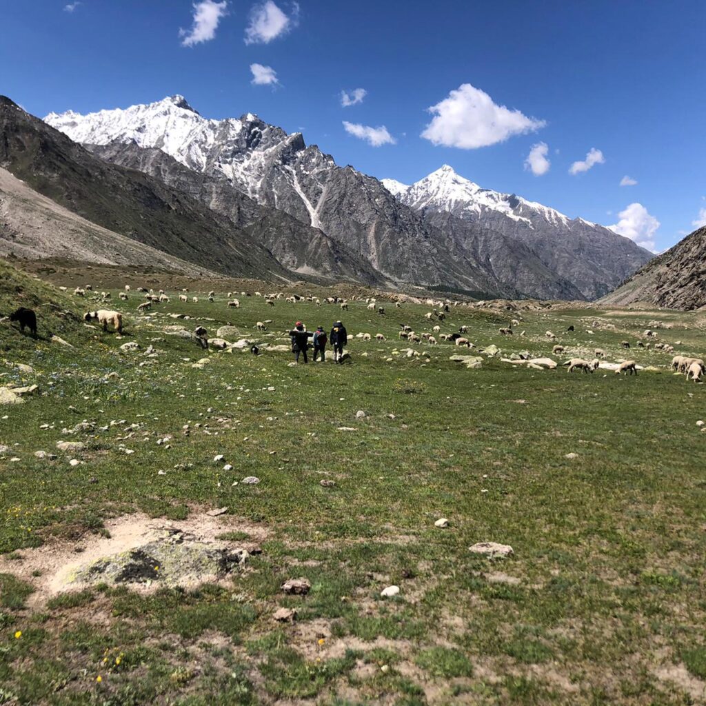
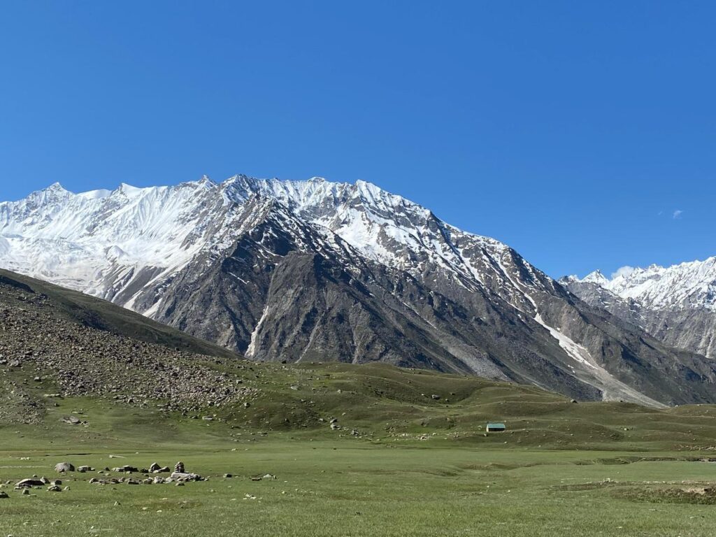
Miyar Valley belongs to the division of Western Himalaya.It is a part of the Lahaul Range, located between Pir Panjal and Zanskar range. The valley is nearly 75 km long and stretches between Udaipur (2649 m) and Kang La Pass (5468 m). More than 50% of area of the Miyar Valley is covered in glaciers. Kang La at the head of Miyar valley is one of the extreme points of India.This valley has given opportunities for trekkers and Climbers and it is a Hub for them to climb many majestic peaks namely Mt.Crystal Peak,Mt.Sanjhana Peak(5940 m), Mt.Tharang peak(6000 m) etc. We Have 6 Nights 7 Days Trek for the Beginners and trekkers on Shepherd trail which gives you fascinating views of Mountains. The wanderers who like to be in nature and spend time for themselves to be completely in it,this is the perfect trek for them. Also The most renowned trek in Miyar valley is Kangla Pass trek which reaches to Zanskar Valley.
Kang-la Pass is a high Altitude trekking which is magnificent and highly challenging trek from one valley to the other. Kang-la Pass was formally used by the Lahauli peoples to cross into the Zanskar and Ladakh region. So it was discovered as a travel route by the local inhabitants earlier, which later on become the strenuous trekking route for rest of the adventurous world. It is the toughest and the most difficult trek which gives one the lifetime experience reaching at the height of 5,450m. This trek can be categorized into the expedition level too, cause of its day to day covered long distances and the terrain so unpredictable. The geography of the valley is changing very fast in the interiors of the Kang-la glacier. So it is not like normal routine trekking, it demands a great effort though it is not for the neophytes. It consists of the great plains of Than Patan to endless moraines, Glaciers and dangerous crevasses. It is kind of technical in a bit, but the gravity of the trek is so hard. This trek takes one from the lush green valleys of Miyar to arid and deserted valley of Zanskar.
Itinerary I
Snout of Glacier Trek
Location: City – Udaipur (Miyar Valley),Lahaul & Spiti, Himachal Pradesh.
Duration: (6 Nights 7 Days)
Trek Type: Moderate – Strennous
Best Season: May-September
Elevation:13100 Ft
Trek Distance:48 Kms
Day 1: Manali to Khanjar (10,500 ft) via Udaipur – 105 km Drive
Meet our Representative and start drive via Atal Tunnel ,Tandi to Udaipur. Lunch on the way visit Trilokinath Temple and then follow the Miyar Nalla reach the last village of the valley Khanjar. Overnight at Homestay.
Day 2: Khanjar to Thanpattan (11,800 ft) via Shukto (11,300 ft) – 4 km
After Breakfast Start trek ,most of the trek is gentle and gives you the view of High mountains. By evening reach the grounds of Thanpattan.
Day 3: Thanpattan to Zardung (12,800 ft) – 10 km
After Breaksfast trek to Gompa and then cross the gompa lake and nalla the trek is flat and has exhilarating view of Mountains.
Day 4: Zardung to Kesar Yon Chhaap (13,100 ft) – 10 km
After Breakfast start trek early as you have to cross few streams which have very cold water.On the way have lunch and enjoy the mesmerizing view of Crystal Peak. Overnight in Camps
Day 5: Kesar Yon Chhaap to Gompa (12,800 ft) – 14 km
Retrace your steps and today we will camp along the Gompa Lake.
Day 6:Gompa to Khanjar(10,500 ft) – 10 km
Trek to Khanjar via Thanpattan .Overnight in Homestay
Day 7:Khanjar to Manali via Udaipur – 105 km Drive
End of the Tour
Trek Itinerary II
Kang La Pass
Region: Manali, Lahaul Valley, Kargil and Ladakh.
Total Duration – 10 Nights / 11 Days
Maximum Altitude – 5500 m/ 18040 ft
Grade – Difficult.
Best Season – Mid June to September
Accommodation – Hotel/Guesthouse; Organized Campsite
Things to Pack:-
- Good pair of trekking shoes with ankle support.
- Clothing: You need to have warm clothes with three-layer jackets, fleece or down feather jacket. Carry 1 or 2 full sleeves t-shirt. For lowers carry cotton pants suitable for trek. Do no carry jeans or shorts for trekking.
- Full body Thermals.
- Socks and Gloves Carry 2 – 3 pair of sports socks along with woolen socks .
- Headlamp/Led Torch are mandatory
- Sunglasses: To protect from sunlight in snow you require UV rays protected sunglasses.
- Lunchbox & Water bottle: Every participant should carry lunch box and water bottle of their own.
- Raincoat/Ponchos: At high altitudes, snowfall and rain are quite common and it’s mandatory to carry a poncho so that one doesn’t get wet.
Day 1: Manali (2050m)-Khanjer(3685 m)
Arrive Manali, Meet our representative and drive from Manali to Udaipur (2,800m/9180ft) 200km. 6-7 hrs. via Rohtang pass (3,980m/13050ft). Koksar, Sissu, Tandi. The drive will take one to the lush green valleys of Manali to dry and rocky landscape of Lahoul Valley. Following the Chandra river will take us to the confluence at Tandi. Where two grand rivers of Lahoul and Spiti valley called Chandra and Bhaga join each other. From this point and ahead the river is called as ‘Chandrabhaga’. After Tandi we drive for a while then take left to the Pattan Valley. On the way many villages, crop fields and monasteries will pass. Udaipur will be reached by the evening. If time allows pay a visit to the historical Mrikula Devi temple at Udaipur. Night stay will be in the local guest house.
Day 2: Drive from Udaipur –Shukto village - Khanjar (3,685m/12080ft) -Tharang
Post Breakfast start trek , we cross a river then climb through the steep trail passing terraced fields, village houses. The trail ahead is moderate with few ups and downs. As we tread forward the beautiful valley of flowers come to show its colours. Then climb toward a ridge top marked by a Chorten(Stupa) for wonderful views. Rest for couple of minutes then continue walking through huge meadows and cross the rivers on temporary bridges. Our camp will be pitched near a stream amidst mighty peaks and wide valley of Miyar in Tharang camping.
Day 3:Trek to Gumba Nala Zardung(3800 m)
Leaving Tharang base camp after breakfast, crossing of ford and through boulders and to vast alpine meadows of Gumba. During summer all these areas carpeted with flowers. After hiking for two hours you reach Gumba nallah (3,800m) and cross the bridge and ascend gradually. Continue through the alpine pasture to Zardung camping. Tharang group of 6000+ peaks remain insight this all day. There is a Takdung glacier stream to be cross next day and afternoon the level of the stream goes up. We camp before this stream in order to cross tomorrow when the level of water will be convenient for crossing.
Day 4: Zardung - Phalpu /(3,985m) (7-8 hr.)
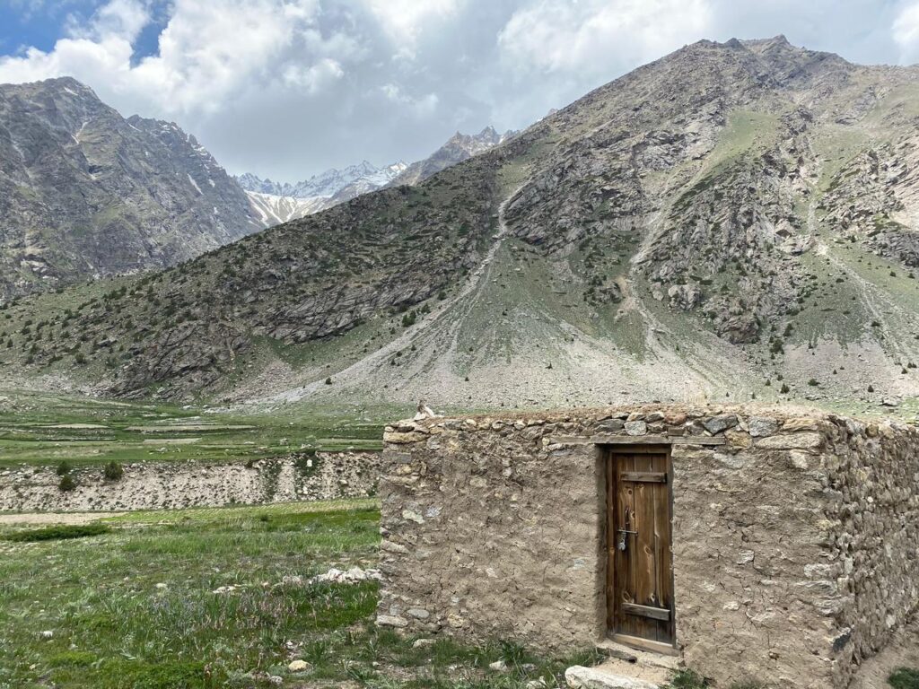
This morning we climb through grassy meadows, hop across several streams all along with rewarding views of peaks and glaciers. As we move deeper into the valley, we surely leave the flowery section behind and barren land ready to welcome. The trail between the wide valley, huge meadows and great mountains keep us fascinating all the way. There are many ideal places for camping but we will try to continue as far as we could cover the distance. The campsite at Alyas is a place of halting sheep on the journey in the mountains. At this place one can see stone huts with or without roofs made by the shepherds. Spend the night gazing the stars.
Day 5: Trek to Glacier Camp I (4,390m) (8-10 hr.)
Following morning we leave early by crossing freezing streams and start climbing on moraine, which will continue till the next campsite. The day is full of difficulties as the moraines are on the slant. These moraines are at such slope that the boulders are sliding slightly downwards and one has to be careful walking on risky terrain. The trail brings all the hardships in terms of boulders, scree and Glaciers. After a strenuous climb the camping will be done on the Glacier field. At night watching the stars shining in the dark sky will take your breath away.
Day 6: Acclimatization day.
Today you will rest for a day and regain your strength for upcoming days.
Day 7:Glacier Camp I – Glacier Camp II Base of Kang-la (4,870m) (9-10hr.)
Start an early move on moraines above the massive glacier field. Soon the moraines will disappear and the glacier field starts. Climb gently on the glacier field that crevasses can be found opened or covered, if covered then take safe route to negotiate it. To avoid any risk, being roped up is very important. The glacier has a gradual increase of gradient and takes way more time than it seems. Climbing hours on the icy field brings us to the camp at immense glacier field below the Kang-la Pass. The pass is clearly visible from this point and we can configure our route for the upcoming climb. The camp II has a very different kind of atmosphere and landscape that makes one to think about the enormity of the Himalayas. The huge snow capped peaks and endless glaciers surrounding the camp makes it perfect site to halt. At night the temperature drops off to –degrees and freezes the area. So sleep well with all your warm clothing’s.
Day 8:Glacier Camp II – Kang-la Pass (5,450m) – Kanjur (4,410m/14460ft) On the other side of the pass (09-10hrs.)
An early start is must to cross over the Kang-la pass to avoid any weather changes at the top, that the weather conditions are unpredictable at such elevation. Climbing in bad weather will turmoil the trek as the crevasses wait ahead and will be invisible at such situation. So the weather holds a significant role to cross over the pass. The climbing continues on the glacier field with gradual to steep gradient for hours. Multiple crevasses of big or small width and depth start to obstacle the route. The climbing towards pass is a strenuous job which needs enough stamina, endurance and will power to conquer Kang-la. The pack will be roped up while crossing over the crevasses and the Pass. We climb zigzag on way around some crevasses. After hours of tiring climb we reach at the top of the Kang-la at 5,450m. From the pass one can see the route left aback and the astonishing vista of snow capped peaks and glistening Glaciers. Now we descend down along the right side of the valley to the stream below the pass. At this point route is moderate but turns into downhill glacier field with moraines and crevasses above it. Soon some vegetation starts to show up of herbal Himalayan plants. The camp III is achieved by the evening after a long tough day. Camp III is located near Tema river on a small meadow surrounded by the rocky mountains. This place is a decent site to halt a night. Watch colourful sunsets painting the sky and the bright morning light with cool breezes blowing aside.
Day 9: Kanjur – Burdan Camping (3,670m/12040ft) (7-8hr.)
Start following the Tema river through rocks and scree. The day’s trek is less difficult than the previous trails. Trailing amidst meadows of wild flowers enchants one in middle of the pure nature. Since entered in the Zanskar valley the landscape gets arid and desolate geographically. This rocky terrain continues till we have a glance of a rough road. We follow a rough road track for 2km. to Bardan Gompa. This monastery is set on the top of riverside cliff and is famous for its 180cm. high mani prayer wheel. We set our camp at Bardan for the night halt.
Day 10:
Burdan – Padum
Last day of the trek few hours and take car for 20 minutes drive to Padum the main city of Zangskar .Overnight stay in Hotel.
Day 11: Padum-Shinkula pass(50 90 m)-Manali
Drive via Shinku la to Manali and Drop in Manali
End of the Tour.
Inclusions:
- Transportation.
- Expert & Certified guide .
- All meals on the trek (Breakfast/Lunch/Dinner,snacks)
- Cooks/Helper and other requisite staff.
- Porters/mules for carrying Trekking gears and Kits
- Equipments – Tents on sharing basis / Sleeping bags / Sleeping Matts, Extra cushion mattresses, Blankets.
- Basic First aid Kit.
- Forest Permits and camping charges.
Exclusions:
- Personal Porters for carrying trekker’s backpacks
- Personal trekking equipments – like trekking poles or sleeping bag liners
- Personal insurance or cost of emergency evacuation
- Purchases of personal natures (like mineral water bottles/bottled or canned beverages/chocolates/dry fruits etc)
- Food to/from the trail head.